A UI/UX Case Study
No. 02 — AURORA CENTRE
The Aurora Interaction Ecosystem
Translating architectural landmarks into adaptive spatial software products.
Role
Interaction & UX/UI Designer
Team Context
Group of 4 Architecture Competition
Recognition
2nd Place Winner (P&T Firm Brief)
Chapter 01
Project Description
Software matching physical subterranean geometry.
- The Site Reality: A landmark concept connected directly to the Dubai Opera and Dubai Fountain while preserving the park's surface footprint.
- The UX Mandate: Turn proposed tech concepts — like proximity wayfinding — into a functional mobile application system.
Project OverviewFig. 01
-15m
Depth below grade
48
Beacon nodes
04
Nav modes
80px
Touch target
— Surface · Burj Park
— -15m · Main Concourse
Chapter 02
Best-in-Class Research
Auditing top physical-to-digital infrastructure spaces.
- The Reference Models: Benchmarked the NYC Lowline underground park alongside proximity setups at the Louvre and Cooper Hewitt.
- The Core Insight: Ambient, passive data updates outperform intrusive interfaces in crowded physical spaces.
Precedent AuditFig. 02
Precedent
Wayfind
Audio
Ambient
Access
Light
Crowd
NYC Lowline
Louvre Proximity
Cooper Hewitt
Aurora (concept)
Chapter 03
Heuristics Evaluation
Preventing navigation failure in underground spaces.
- The Environment Constraint: Standard GPS mapping fails underground, introducing spatial disorientation risks at pathway junctions.
- The Fix: Shifted interface navigation toward automated proximity triggers and ambient hardware feedback.
Heuristics — RedlineFig. 03
Heuristic
Before
After
Wayfinding clarity
GPS fails -15m
BLE proximity mesh
Sensory load
Loud PA overlays
Personal audio stream
Accessibility
Tiny 28px taps
80px ramp-safe taps
Light adaptation
Static bright UI
Depth-aware theme
Chapter 04
Service Blueprint
Connecting human steps directly to interface actions.
- The Ecosystem Matrix: Aligned physical walking paths with front-stage screens and back-stage proximity hardware loops.
- The Interaction Balance: Managed spatial tracking sensors alongside personal audio channels to ensure a fluid experience.
Chapter 05
Stakeholders & Analytics
Adapting interface behavior to environmental realities.
- The Urban Constraints: Balanced massive tourist influxes with localized background noise from the Dubai Fountain.
- The Audio Strategy: Routed exhibition audio narratives through personal device streams to preserve structural silence inside.
Contextual SynthesisFig. 05
Tourist density62%
Fountain decibels78dB
Shade dwell zones04
Auto-dim triggers12
Walking speed drops ~38% within shaded courtyards — notifications batch until natural rest points.
Chapter 06
Ethnographic Field Study
Timing interface alerts based on pedestrian habits.
- The Behavioral Finding: Tracked park users to find that walking speeds drop predictably inside shaded microclimates and courtyards.
- The Timing Rule: Programmed application notifications to hold alerts until users naturally slow down within structural rest spots.
Behavioural TimingFig. 06
Chapter 07
Opportunity Documentation
Grouping abstract concepts into prioritized updates.
- The Three Product Tiers: Organized feature roadmaps into ambient navigation, interactive exhibits, and personal exploration logs.
- The Input Refinement: Filtered potential features based on crowd patterns, safety layouts, and language accessibility.
Opportunity MatrixFig. 08
High ImpactHigh EffortLow Effort
Proximity Wayfinding
Adaptive Audio Lanes
Ambient Dashboard
Exploration Log
Chapter 08
Vision Concept
The interface as an organic extension of structural paths.
- The Screen Style: Avoided traditional menu bars for a gesture-driven dashboard that shifts color based on user depth.
- The Exploration Mode: Background services automatically fetch localized scripts and audio logs without requiring manual input.
Vision ConceptFig. 09
The space is the hero.
Interface dissolves into depth.
Interface dissolves into depth.
- 01Gesture-driven dashboard
- 02Theme shifts with depth
- 03Background audio fetch
- 04Zero-input wayfinding
Chapter 09
Qualitative User Testing
Optimizing automated synchronization for international groups.
- The Interaction Barrier: Early testing showed that manual QR entry nodes caused immediate pedestrian line backups.
- The Optimization: Expanded Bluetooth beacon range to automate language check-ins, removing physical lines entirely.
Usability ValidationFig. 10
Language check-inQR queue→Auto · 2s
Find exhibit3m 41s→0m 28s
Quiet-zone audioManual mute→Auto-dim
Chapter 10
User Flows
Connecting layout coordinates directly to interface responses.
- The Core Profiles: Mapped separate navigation pathways for open exploration, rapid transit, and low-mobility routing.
- The Context Hook: Stepping into specialized chambers reduces display brightness to zero while launching personal audio feeds.
User FlowsFig. 11
Chapter 11
Hi-Fi Designs
Synchronizing screen themes with physical site conditions.
- The Light Adaptability: The user interface changes from a bright paper layout outdoors to an ink dark mode underground.
- The Style Choice: Combined Inter Tight data tables with Instrument Serif headlines to match building textures.
Hi-Fi DesignsFig. 13
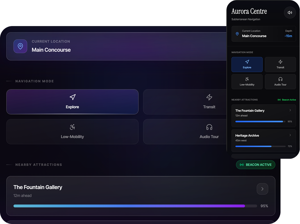
- Typographic system. Instrument Serif headlines paired with Inter Tight UI for subterranean legibility.
- Four navigation modes. Explore · Transit · Low-Mobility · Audio Tour — all on accessible 80px touch targets.
- Beacon proximity. Live nearby-attraction tracking with signal-strength meters.
- Depth awareness. Persistent location chip surfaces current depth (-15m · Main Concourse).
- Audio streaming control. Integrated stream toggle preserves structural silence.
- Adaptive dark theme. Subtle gradients let the physical space remain the hero.